Historically, infrastructure planning has prioritized the expertise of technical professionals over input from community members. But without a shared understanding of what a community needs, projects may remain incomplete or stalled, leaving marginalized communities particularly vulnerable to worsening climate impacts.
To revitalize the L.A. River for a modern climate, where both flood protection and community engagement lead, requires an innovative approach to infrastructure design.
The Approach
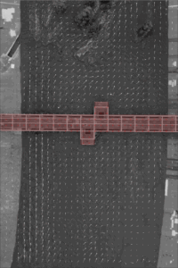
To develop a new design approach that would bring together engineers and community members, the L.A. River Project team focused on a section of the river vulnerable to flooding, called the Glendale Narrows. As described by the LA Times, this is the only major segment of the 51-mile-long L.A. River not designed to withstand a major flooding event, which is more and more likely to happen in a changing climate. While temporary measures have been taken, a comprehensive solution to protect lives and livelihoods is urgently needed.
Main photograph by Gina Clyne courtesy of Clockshop’s program ‘What Water Wants.’
Research Verticals
-
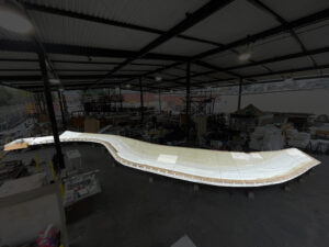
A PHYSICAL MODEL
A 60-foot physical model of the Glendale Narrows accurately represents the river and provides scale simulations of water flows and geological features.
-
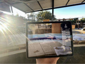
INFORMATION RICH AUGMENTED REALITY VISUALIZATIONS
The augmented reality (AR) system was developed to work with the physical model, allowing a user to hold a tablet up to the model and see additional information such as what different levels of flooding would look like, identify landmarks, or learn more about how climate is changing the river. By using a tablet instead of virtual reality glasses, it allows users to actively participate in real world conversations with each other and share their learning experiences.
-
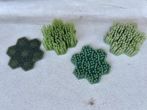
INTERACTIVE DESIGN FEATURES
As community members often ask for more landscaping to be restored to the L.A. River, the team designed magnetic “pick and place” landscaping for the physical model. Designed to mimic the impact of landscaping on the flow of water in the river, users can landscape the river themselves by placing 3D printed “plants” of varying sizes in the physical model.
-
REAL WORLD DATA COLLECTION
Real time data from the river — including flows, temperature, sediment, etc. — will become available in late 2024. This data will help support planning and monitoring of river restoration efforts.
The Bureau of Engineering is the City of Los Angeles’ lead agency for the revitalization of the L.A. River and have delivered multiple successful projects including the L.A. River Revitalization Plan, the L.A. River Bikeway, three L.A. River pedestrian bridges, the Sepulveda Basin Vision Plan and multiple other ongoing projects.
With environmental sustainability as a guiding principle, the U.S. Army Corps of Engineers is working diligently to strengthen our Nation’s security by building and maintaining America’s infrastructure.
![]()
![]()
The Results
To test whether our new approach improved communication between community members and technical experts we organized a series of focus groups, totalling 25 participants. Participants were from both technical and non-technical backgrounds and represented community members, river advocates, landscape architects, artists, and representatives from government.
- The focus groups delivered promising results, with technical experts from the City calling the tool’s potential “mind blowing” and community members already requesting the tool be used in the City’s community engagement process. Participants remarked on the awe of seeing the physical model with water running through it, and urged the USC team to use the tool not only for community engagement on specific projects, but for educational purposes, noting its ability to help users visualize complex design and climate challenges.
In the News