Climate & Sustainability / Health & Wellbeing
Helping Families by Monitoring Soil Safety after the LA Fires
About CLEAN
Sign up for our newsletter!
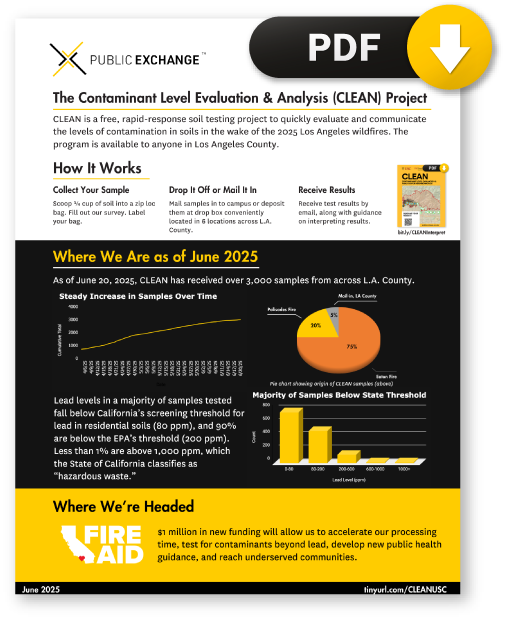
Contaminant Level Evaluation and Analysis for Neighborhoods (CLEAN) is a rapid response soil testing program from the USC Department of Earth Sciences, Keck School of Medicine, and Public Exchange. CLEAN is a free service provided to all L.A. County residents to evaluate levels of lead contamination in soils in the wake of the Los Angeles wildfires.
CLEAN is currently testing all soil samples for lead contamination. Lead is hazardous to human health. CLEAN is also broadening its scope to test some samples for additional contaminants, such as polycyclic aromatic hydrocarbons (PAHs). Check back soon to see what additional contaminants will be added to our analysis. Your CLEAN results can identify areas where more in-depth investigation or testing is needed.
CLEAN is a project from USC, and is separate from L.A. County Department of Public Health soil testing. If you are looking for L.A. County’s Eaton soil testing program, please visit their website.
On This Page:
-
- How to Participate in CLEAN
- Drop Box Locations
- Accessing Your Results
- Read our preliminary takeaways
- View the Sample Map
- The TRACE Project
Participating in CLEAN
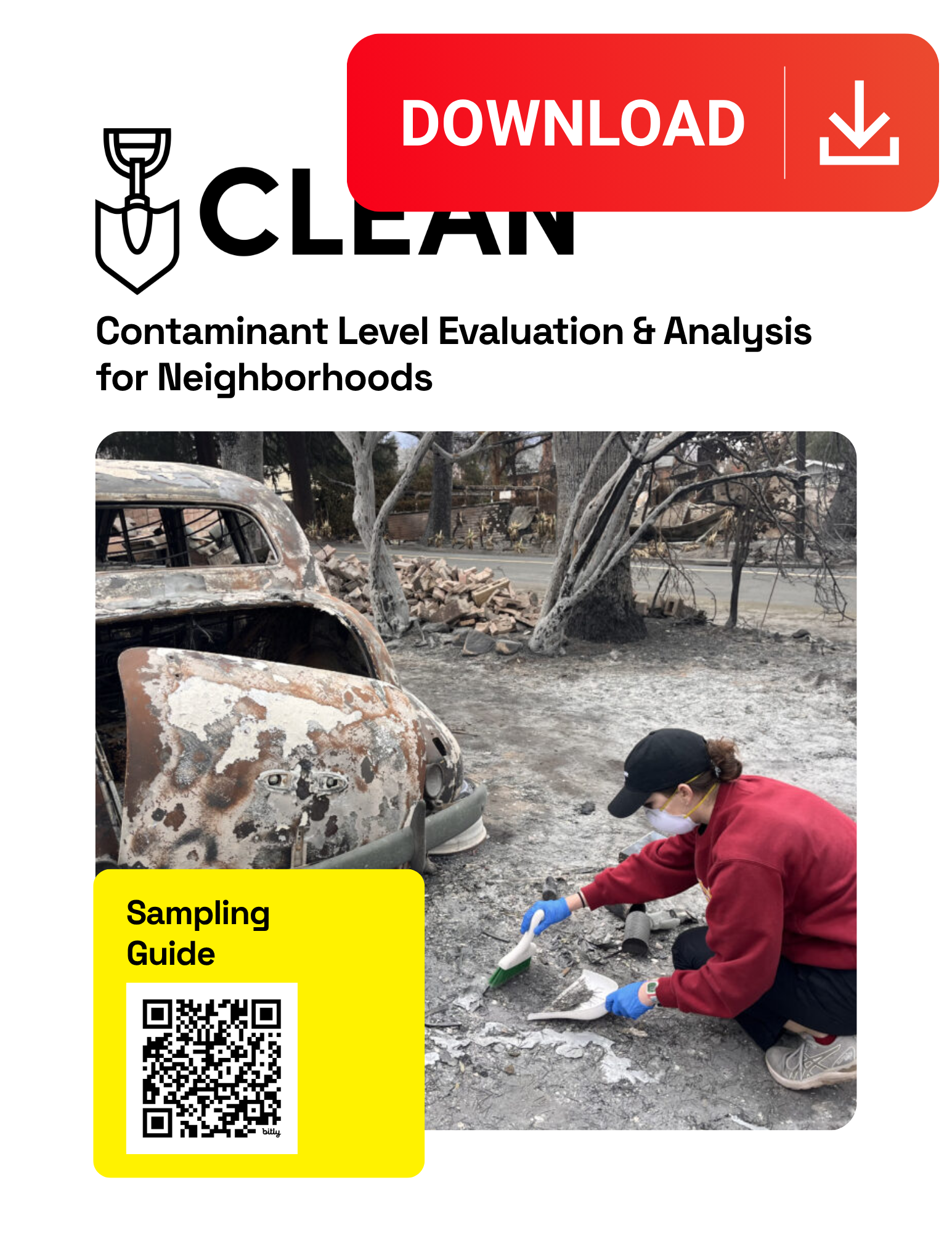
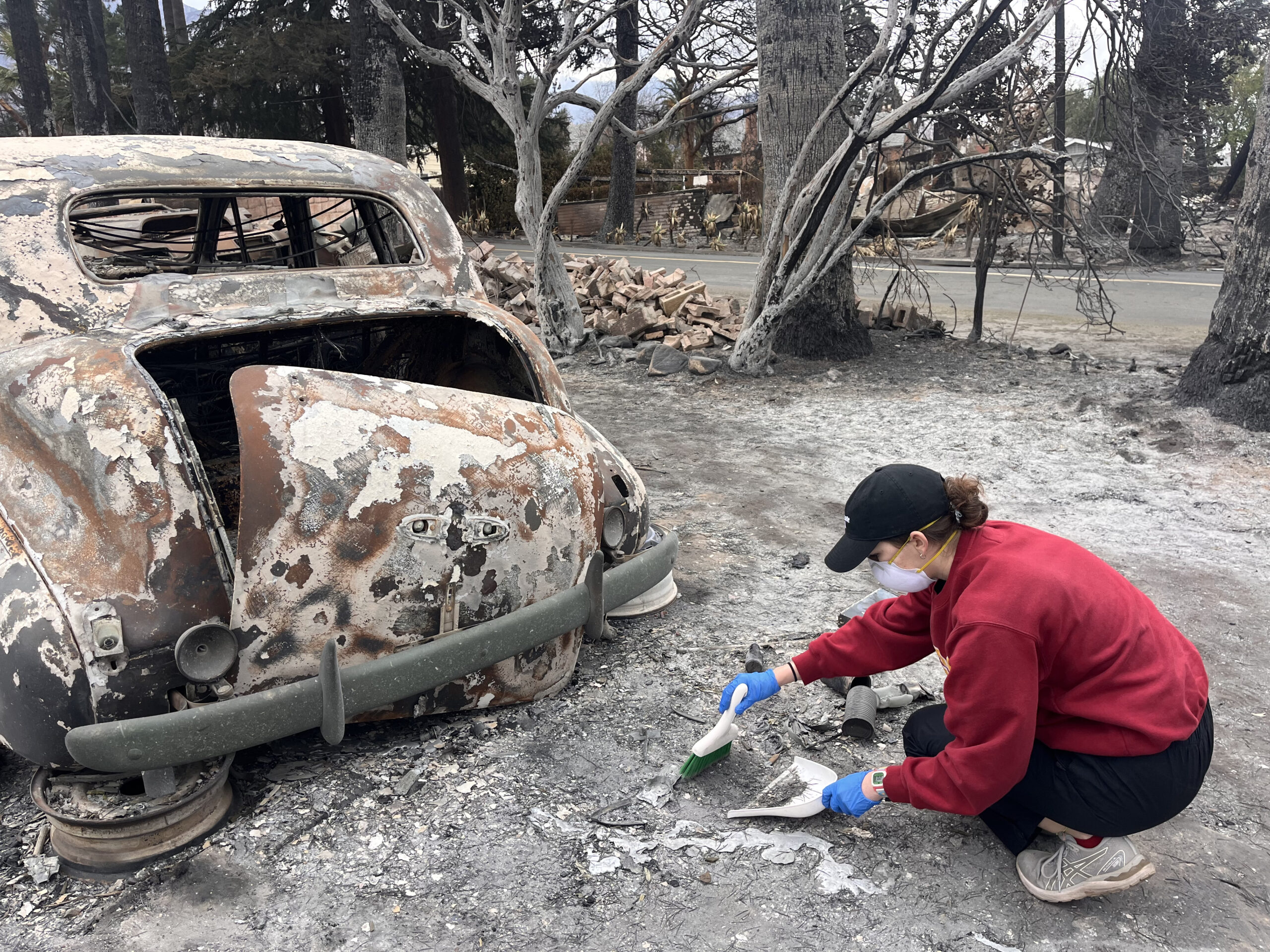
- Review our sampling guide in its entirety to learn how to collect your sample safely (download on the left | Español).
- Complete our intake survey and receive your Unique Sample ID–this is required before we can test your sample | Español.
- Bring your soil sample to one of the drop-off locations, or mail your sample directly to USC.
- See our frequently asked questions | Español.
This testing is rigorous and reliable, but it is not a substitute for the kind of in-depth environmental testing or remediation that may be needed for some areas. This testing is designed to quickly provide Los Angeles residents with general updates on safety and the potential for exposure, augmenting other efforts that may be underway, including from government agencies. It’s important to note that USC’s testing is not as comprehensive as the testing conducted by government agencies or environmental remediation experts, nor is it meant to be used for regulatory compliance with State and Federal requirements for remediation.
Submitting Your Sample
You can submit samples to the CLEAN project by mail or at one of the following community-based drop-off locations. If you would like to suggest a drop-off location in your community, or you would like to volunteer your business/organization as a location, please contact the project team at cleanproject@usc.edu. Samples will not be accepted in-person on USC’s campus—please make use of our designated drop boxes or mail in your sample.
You cannot submit samples for L.A. County Department of Public Health’s Eaton soil testing program at any of these locations.

By Mail:
To mail samples, you must pay for your own postage and ship samples to:
CLEAN Project
3651 Trousdale Parkway
USC ZHS 117B
Los Angeles, CA 90089
Drop Off Locations:
Please note the hours that samples will be accepted. Be sure to replace the lid of the bin after you’ve deposited your sample.
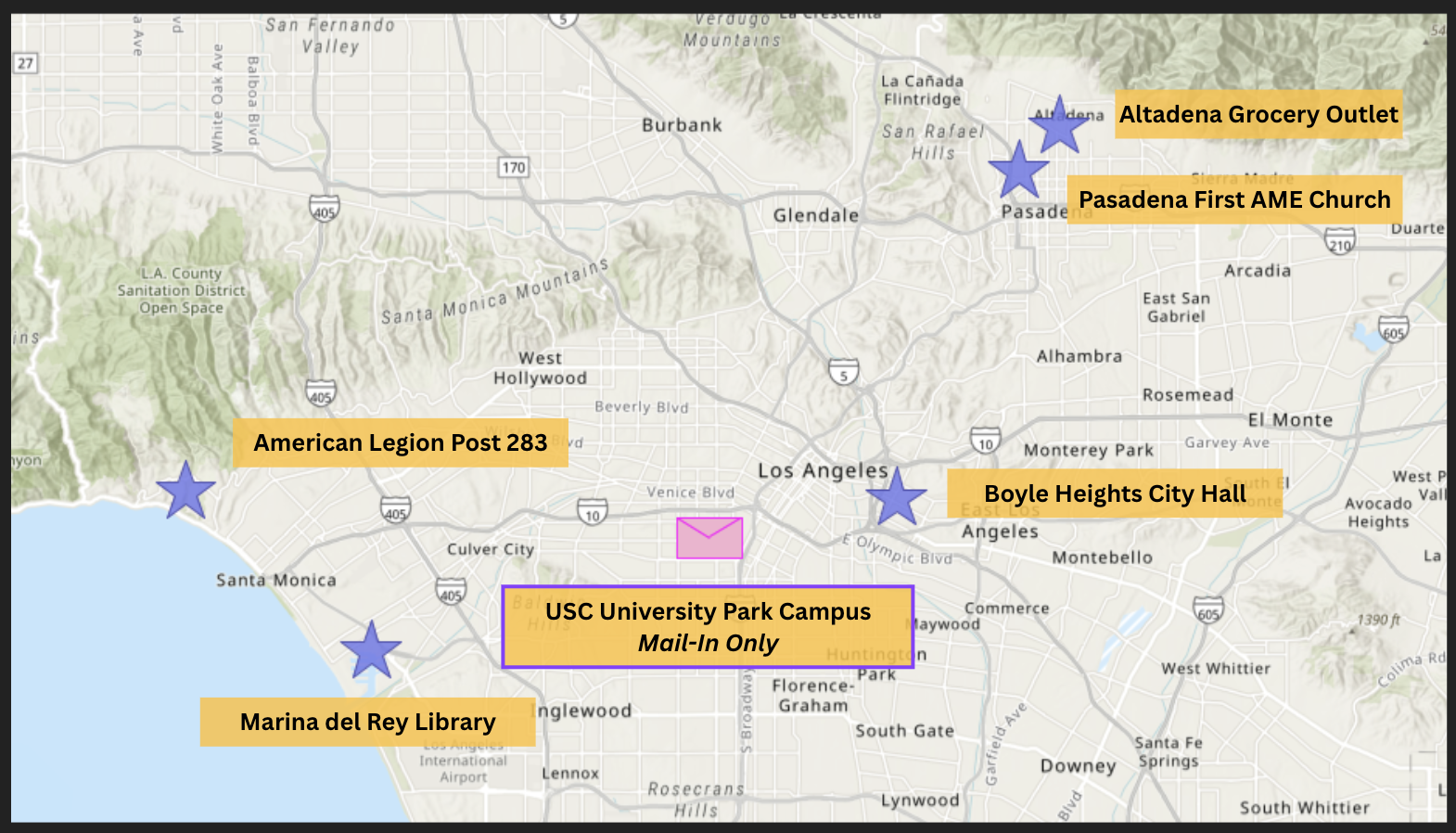
Palisades Fire
American Legion, Post 283
15247 La Cruz Dr, Pacific Palisades, CA 90272
Mon–Sat: 9 AM – 5 PM
Lloyd Taber-Marina del Rey Library
4533 Admiralty Way, Marina del Rey, CA 90292
Mon–Thu: 10 AM – 8 PM |
Fri–Sat: 10 AM – 6 PM | Sun: CLOSED
Eaton Fire
Altadena Grocery Outlet
2270 Lake Ave, Altadena, CA 91001
Open daily: 9 AM – 7 PM
Pasadena First AME Church
1700 N Raymond Ave, Pasadena, CA 91103
Tues–Sun: 10 AM to 4 PM
Boyle Heights City Hall
2130 East 1st Street Los Angeles, CA 90033
Mon–Fri: 9 AM–5PM
Accessing Your Results
Results will be uploaded to this google sheet as soon as possible, and mapped onto the interactive map. You will be notified by email as soon as your results are ready—typically within 4-6 weeks of the date when you drop off your sample.
For help understanding your results, recommendations for precautionary measures to reduce your and your family’s risk of exposure, and additional resources, please see our lead interpretation guide (download on the left).
Understanding Your Results: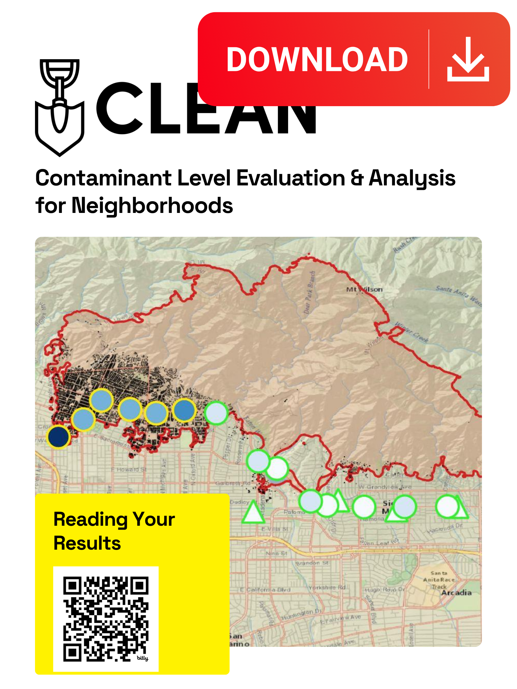 Download PDF guide
CLEAN Results
Click below to read our preliminary results!
Sample Map
The map above will be updated regularly as new samples are processed and analyzed.
Wildfire Smoke Map
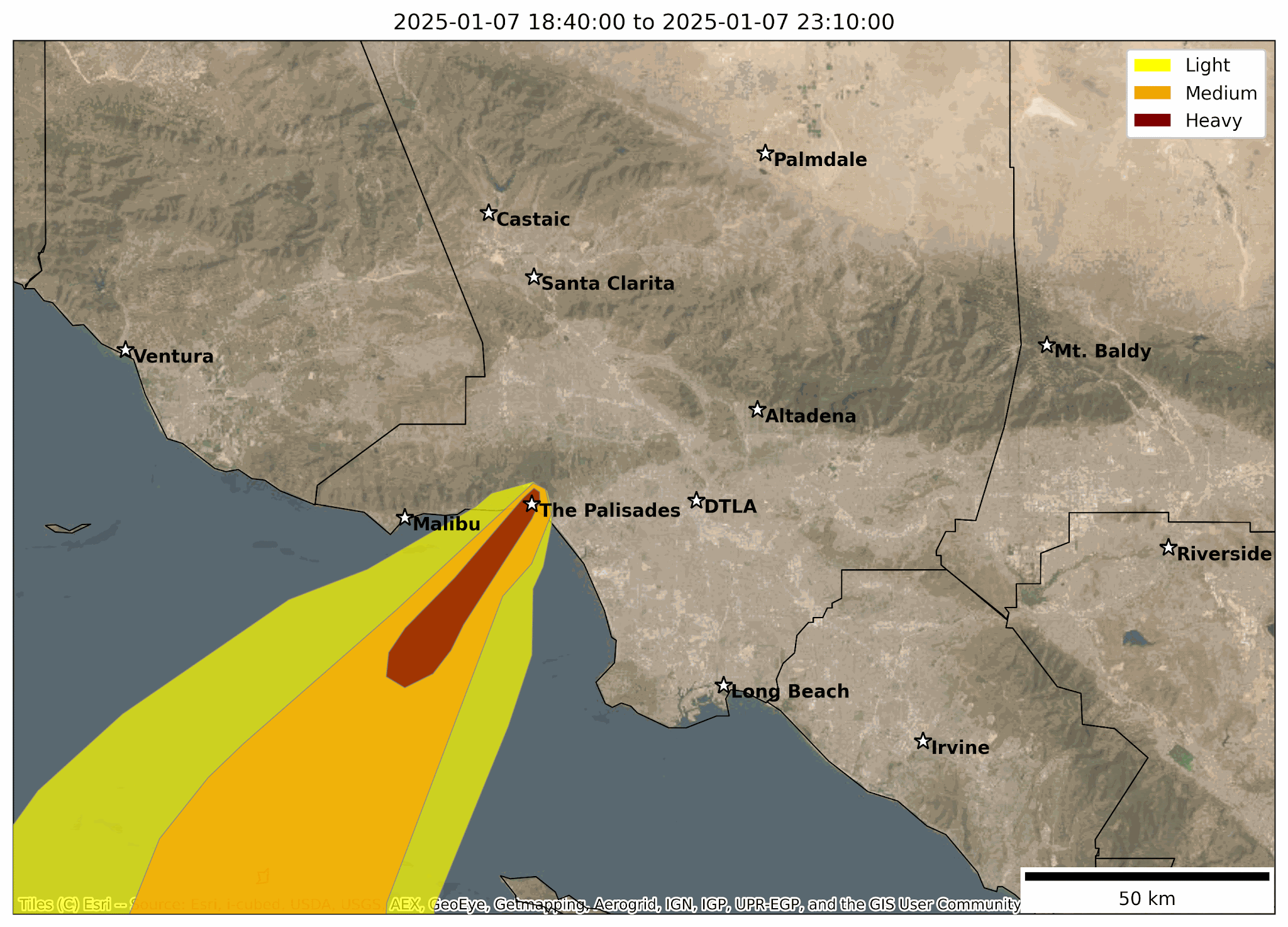
The animation above represents the movement of smoke across the Los Angeles area between January 7 and January 24, 2025, with dark red patches representing extremely smoky conditions (“heavy” smoke) and yellow representing less smoky air (“light” smoke). This is an estimate of the smoke’s behavior—the boundaries between orange and red, for example, should not be interpreted too precisely. The team expects that areas that were covered in red and orange plumes, particularly over consecutive days, may have greater overall exposure to pollution from the fires.
The Temporal Resampling and Analysis of Contaminants in the Environment (TRACE) Project
The TRACE project provides monthly post-fire contamination data from samples of roadside dust in Altadena. Currently testing only for lead, TRACE samples the same locations over time to explore how contamination is changing in the months after the fires.
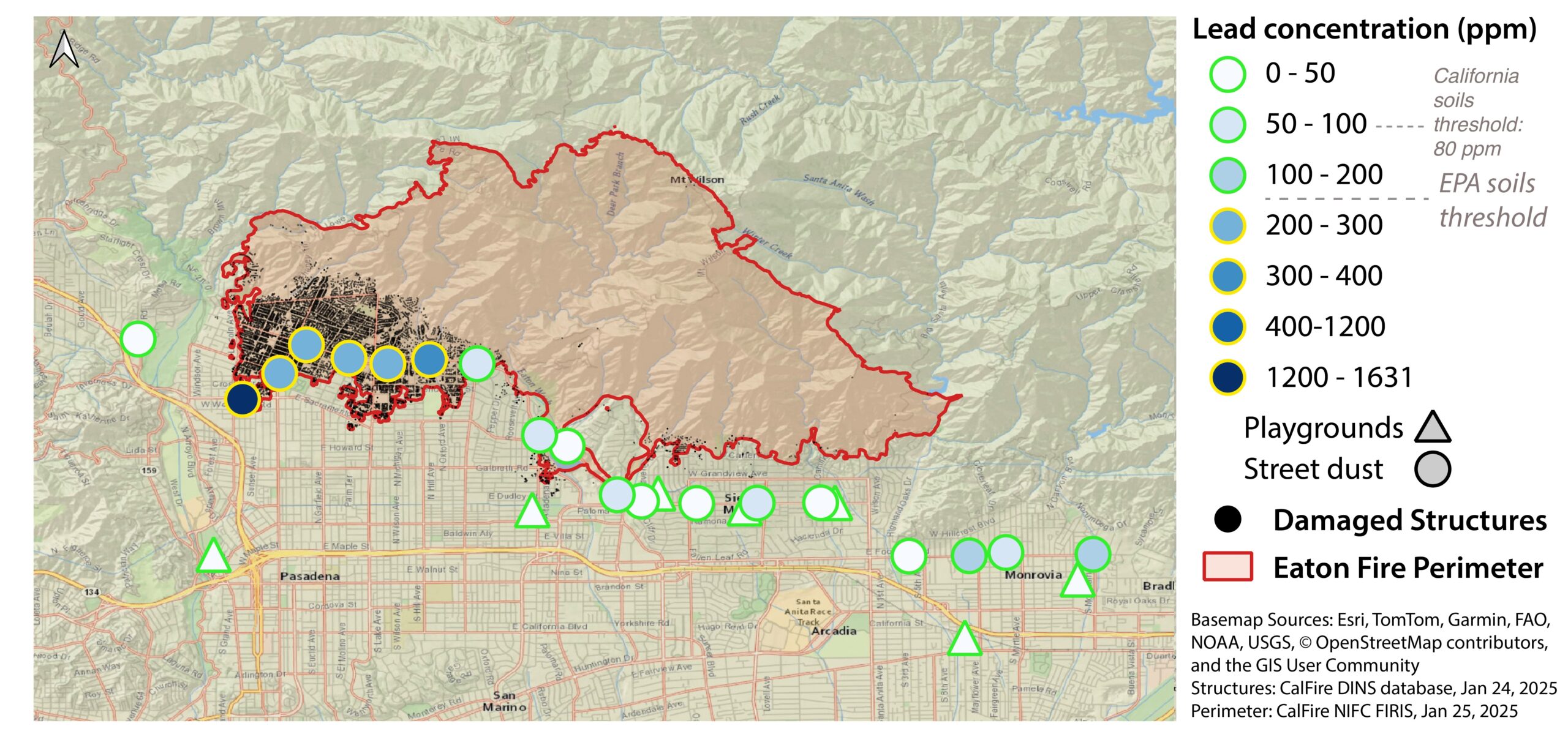 The map above depicts lead concentration (ppm) in playground sand and street dust at TRACE sampling locations from January, 2025.
For the most recent TRACE sample results, please view our interactive map.
-
- Early results show the highest lead levels are found in areas directly affected by the fire, with levels dropping farther away.
- In the center of the Eaton Fire burn zone, some roadside dust samples exceed state and federal safety limits for lead in residential soil.
- Lead levels in playground sand are low in all tested locations, even those covered in ash.
- Overall, playground sand does not appear to be a major source of lead exposure.
The researchers behind this analysis are Los Angeles residents and parents, and they find these results reassuring, particularly for areas outside of the burn zone. These findings can inform what actions and precautions other residents might feel comfortable taking—like sending children back to school.
Frequently Asked Questions
Visit bit.ly/CLEANFAQ to learn more about the project and how to interpret your results.
Support CLEAN
Your donations help support the team that retrieves and tests samples, and builds capacity for testing a wider array of contaminants in the future. Click here to make a donation.
Project Team Members
Cat Odendahl
USC Dornsife Earth Sciences
PhD Student
Project Advisor
Public Health Sciences
Newsroom